Map Reading Basics: How to Read Topographic Maps - Lines, Symbols, and Coordinates
- Aug 1, 2025
- 7 min read
Updated: Nov 5, 2025
The Ultimate Guide to Understanding, Navigating, and Mastering Topographic Maps in the Wild

After 12 years of teaching survival in the Air Force—including countless land navigation drills—I’ve seen it all. From rookie mistakes to total "I have no idea where I am", I've coached people through every misstep imaginable (thanks, lieutenant). Those lessons taught me not just how to navigate terrain, but how to teach it clearly and practically.
Land nav can feel overwhelming, but it’s not as complex as it seems. In fact, you probably already have the instincts—you just need to learn how to apply them to a map and compass.
This guide will walk you through everything you need to know to read a topographic map with confidence and maybe even save your life one day.
Lost Isn’t an Option: Why Map Reading Still Matters
In the age of smartphones, GPS, and built-in navigation, knowing how to read a topographic map might seem outdated, until it’s not. When your batteries die, you lose your phone, it breaks, the signal vanishes, or your device malfunctions, a map and compass become your best friend. Understanding the basics could very well save your life.
Topographic maps are the gold standard for navigating natural terrain. They show in-depth details like elevation changes, ridgelines and drainages, peaks and valleys—things digital apps like Google Maps just don’t capture. That’s why skilled hikers, survivalists, and even first responders still rely on them regularly. These skills aren’t just for show—they’re the foundation of true navigation.
Over the past few years, interest in map reading seems to have surged, especially within the prepping and outdoor communities. With more people venturing off-grid, the need to read terrain without a screen has made a serious comeback. Also, you never know when a GPS could be wrong (intentionally or not), the government can't change your map and compass.
Learning to read a topographic map isn’t overly complicated, though the map may look that way, and this guide will show you how. Let’s dig in.

Lines, Legends, and the Land: Decoding the Details
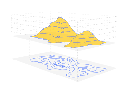
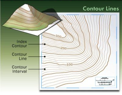
1. Contour Lines: Reading Terrain at a Glance
Contour lines take our 3D world and put it on a flat surface. Once you learn how to read them, you'll start to see all the hills, peaks, valleys, drainages, and more. They not only help you figure out where you are, but also allow you to read and understand the landscape around you.
A contour line is a line that shows constant and unchanging elevation. Think of the shoreline of a lake—that's a natural contour line. These lines represent equal elevation and help you visualize the shape of the land. The closer the lines, the steeper the terrain, while wider spacing means a more gradual slope. The other terrain features are below.
Peaks: Closed circles—smallest circle marks the summit.
Ridges: U- or V-shaped lines pointing downhill (away from peak), forming narrow high ground.
Drainages: V-shaped lines pointing uphill (toward peak), low area and may have water.,
Index Lines: Usually every fifth line is darker and marked with elevation—use these to measure elevation changes.
Spacing: Close lines = steep; wide lines = flat.
Below are a few photos to help represent this. If you want a full breakdown of how to read them, check out my video here.

2. Map Scale: Understanding Distance
The map scale, usually found at the bottom of the map in the legend, shows how distances on the map relate to real-world distances. For example, a 1:24,000 scale means 1 inch on the map equals 24,000 inches (or 2000 feet) on the ground. Understanding scale is key to judging how far you'll actually travel or how far you are from something. It's how you measure distance.
If you're going to get serious about topographic maps, learn and get used to the metric system. Our grid systems, discussed later, all use kilometers, not inches and miles. If you don't know, the rough conversion is 1mile =1.6 kilometers OR 1kilometer =.62 miles.
For more details and the latest news we host classes, webinars, and more. To stay up to date subscribe to our newsletter.

Smaller scale (e.g., 1:24,000) = more detail, less area covered. Great for hiking, backpacking, or terrain analysis.
Larger scale (e.g., 1:100,000) = less detail, more area shown. Better for general planning, not fine navigation.
For accurate land navigation, especially on foot, stick with maps that are 1:50,000 or more detailed. Anything beyond that sacrifices too much detail to be reliable in the field. Choose the right scale based on how much you need to see and how precise your movement needs to be.

3. Grid Lines and Coordinate Systems: Conveying Location
Grid lines divide the map into a series of squares, creating a coordinate system that helps you pinpoint exact locations. Learning how to read these is a post all on its own. Today, we're just focusing on knowing that they are important, what they are, how they appear, and why they matter. For a great tool to learn and play around with grid systems, I use this ---> here.
Most topographic maps use one of two common systems:
UTM (Universal Transverse Mercator) / MGRS (Military Grid Reference System) {MOST COMMON}
Latitude and Longitude
UTM / MGRS (same grid, different numbering system)
UTM divides the world into zones and gives coordinates in meters east and north of a baseline. MGRS is a military version of UTM that simplifies this into a lettered grid. You'll typically see these marked with blue or black grid lines across the map, often labeled along the edges with large numbers (e.g., 16S 12345678).
Look along the map margins to find the UTM zone and grid spacing.
These squares are usually 1,000 meters across on 1:24,000 maps.
With most larger scale maps (1:24000 / 1:50000) you'll typically find the grid zone designator - e.g., 16S - in the legend/marginal information.


Latitude and Longitude
This system uses degrees, minutes, and seconds to measure how far north/south and east/west a point is from the Equator and Prime Meridian. You’ll see these marked with small tick marks or labels along the edges of the map (e.g., 30°15'00"N, 86°30'00"W).
Latitude lines run horizontally; longitude lines run vertically.
They are often curved slightly to account for Earth’s shape.
You’ll usually find both systems noted in the legend or map margin, usually near the scale bar or declination diagram. Some maps show both grid systems at once—don’t let that overwhelm you. Just know those grid lines are how you’ll communicate location precisely when the time comes.
4. Map Legends and Symbols: Decoding the Details
The legend—or key—is your quick reference to understanding everything else on the map. It explains what the symbols, lines, and colors mean so you’re not left guessing.
Topographic maps use a set of symbols to show natural and manmade features:
Black: Manmade structures (buildings, roads, bridges, etc.)
Blue: Water features (rivers, lakes, swamps)
Green: Vegetation (forests, orchards, dense growth)
Brown: Contour lines (elevation)
Red or Purple: Major roads, boundaries, or map updates
The colors may change from map to map however you'll almost always find them in the legend.
Common symbols include railroads, power lines, trails, campgrounds, towers, and more—each one is explained in the legend, usually found in the map margin.
Keep in mind: manmade features change. Buildings get torn down, new roads get built, and trails shift over time. That’s why older maps can be unreliable when it comes to anything humans have created. Always check the map’s publication date and cross-reference with current data when possible.
The legend is your best friend when interpreting unfamiliar symbols—and it’s the first place you should look when something doesn’t make sense on the map. This example is quite extensive, however keep in mind if it's in the legend, there is a very good chance it will be found on the map. It's unlikely the legend contains symbols that aren't used.

Can You Read the Ground Like a Local? You Can Now
By now, you’ve got a solid understanding of how to read a topographic map—from contour lines and elevation to map scale, grid systems, and symbols. What once looked like a chaotic mess of squiggles and colors should now feel like a clear, readable story of the land.
So what’s next? Start small: grab a topo map of your local area, lay it out, and try to match the map features to the world around you. Identify a nearby hill, a water source, or a ridge and find it on the map. You can even mark your house and see how accurate the manmade features still are.
If you’re looking to gear up, Here is my go-to resource, including quality topographic maps and map-reading tools.
We also offer hands-on map and navigation training through Six Point Survival—perfect for those wanting to build real-world confidence. Check out our upcoming classes or reach out for private group sessions.
Don't miss any of our updates and new classes by subscribing to our newsletter here! Still have questions? Drop them in the comments. Let’s keep building skills together—one line at a time.
Want More?
If you found this guide helpful, there’s plenty more to learn. Subscribe to our Six Point Survival Newsletter for monthly tips and field-tested gear advice, and check out our YouTube channel for real-world demos and survival lessons.
Your support keeps Six Point Survival running — and trust me, caffeine is cheaper than therapy.
~ Micah Gillette
Donate to our Coffee Fund Now